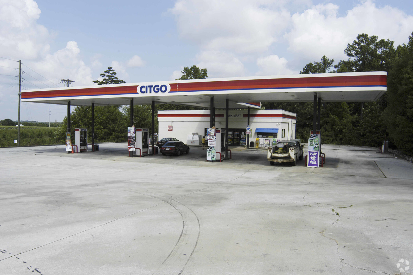
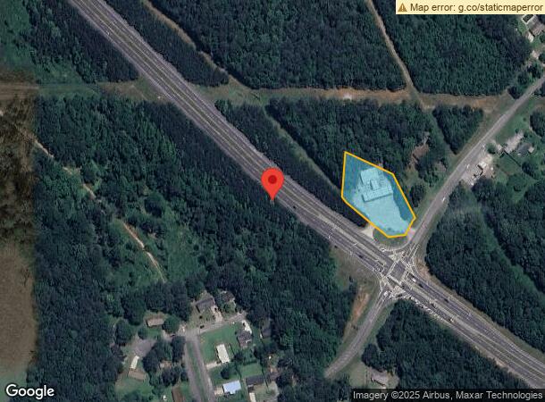
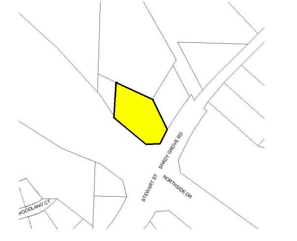
Property Record
801 Northside Dr, Carrollton, GA 30117
NEARBY LISTINGS FOR SALE OR LEASE
Property Detail
801 Northside Dr
C03-0270072
Charles Holloway Surv
Storebuilding
COMM BLDG/1.08AC 801 NORTHSIDE DR C20
X
Carroll
13045C0256D
Georgia
2024
1.08 AC
2024
Villa Rica/W Outlying
910600
Atlanta
2,400 SF
Atlanta-Sandy Springs-Roswell, GA
DEMOGRAPHICS near 801 Northside Dr
1 Mile
3 Mile
5 Mile
2024 Total Population
2,391
25,579
47,515
2029 Population
2,604
28,394
52,744
Pop Growth 2024-2029
+ 8.91%
+ 11.01%
+ 11.00%
Average Age
38
36
36
2024 Total Households
996
9,624
17,071
HH Growth 2024-2029
+ 9.04%
+ 11.07%
+ 11.19%
Median Household Inc
$51,059
$44,194
$47,990
Avg Household Size
2.30
2.50
2.60
2024 Avg HH Vehicles
2.00
2.00
2.00
Median Home Value
$173,220
$179,251
$208,479
Median Year Built
1981
1984
1987
Nearby Places
- Restaurants
- Banks
- Shops
- Fitness
- Groceries
Nearby Properties
Address
Land Use
TOTAL SIZE
Lot Size
Zoning
Address
Land Use
TOTAL SIZE
Lot Size
Zoning
50,000 SF
28.63 AC
HS
Address
Land Use
TOTAL SIZE
Lot Size
Zoning
106,769 SF
11.26 AC
HS
Address
Land Use
TOTAL SIZE
Lot Size
Zoning
1,542,912 SF
118.16 AC
M2
Address
Land Use
TOTAL SIZE
Lot Size
Zoning
152,962 SF
108.90 AC
OI
Address
Land Use
TOTAL SIZE
Lot Size
Zoning
39,268 SF
12.05 AC
RM-10
Address
Land Use
TOTAL SIZE
Lot Size
Zoning
134,113 SF
2.80 AC
OI
Address
Land Use
TOTAL SIZE
Lot Size
Zoning
73,900 SF
10.57 AC
C2
Address
Land Use
TOTAL SIZE
Lot Size
Zoning
820,922 SF
84.15 AC
M2
Address
Land Use
TOTAL SIZE
Lot Size
Zoning
162,506 SF
23.32 AC
M2
Address
Land Use
TOTAL SIZE
Lot Size
Zoning
56,458 SF
21.87 AC
R3
Address
Land Use
TOTAL SIZE
Lot Size
Zoning
12,752 SF
15.63 AC
R3
Address
Land Use
TOTAL SIZE
Lot Size
Zoning
19,960 SF
0.53 AC
HS
Address
Land Use
TOTAL SIZE
Lot Size
Zoning
17,102 SF
33.57 AC
R3
Address
Land Use
TOTAL SIZE
Lot Size
Zoning
7,700 SF
7.08 AC
R3
Address
Land Use
TOTAL SIZE
Lot Size
Zoning
17,000 SF
13.52 AC
R3
Address
Land Use
TOTAL SIZE
Lot Size
Zoning
276,510 SF
6.78 AC
M1
Address
Land Use
TOTAL SIZE
Lot Size
Zoning
44,708 SF
9.92 AC
RESIDENTIA
Address
Land Use
TOTAL SIZE
Lot Size
Zoning
170,850 SF
10.97 AC
M2
Address
Land Use
TOTAL SIZE
Lot Size
Zoning
341,714 SF
44.49 AC
M2
Address
Land Use
TOTAL SIZE
Lot Size
Zoning
117,105 SF
8.74 AC
M2
Address
Land Use
TOTAL SIZE
Lot Size
Zoning
90,800 SF
10.89 AC
C2
Address
Land Use
TOTAL SIZE
Lot Size
Zoning
28,554 SF
0.74 AC
002
Address
Land Use
TOTAL SIZE
Lot Size
Zoning
128,000 SF
0.74 AC
M2
Address
Land Use
TOTAL SIZE
Lot Size
Zoning
42,905 SF
9.76 AC
002
Address
Land Use
TOTAL SIZE
Lot Size
Zoning
19,840 SF
10.37 AC
R2
Address
Land Use
TOTAL SIZE
Lot Size
Zoning
9,891 SF
11.54 AC
R3
Address
Land Use
TOTAL SIZE
Lot Size
Zoning
30,985 SF
3.24 AC
HS
Address
Land Use
TOTAL SIZE
Lot Size
Zoning
3.23 AC
C1
Address
Land Use
TOTAL SIZE
Lot Size
Zoning
45,480 SF
62.18 AC
R20
Address
Land Use
TOTAL SIZE
Lot Size
Zoning
130,493 SF
14.34 AC
C2
The World's #1 Commercial Real Estate Marketplace
Connect with us
© 2025 CoStar Group
The information above has been obtained from sources believed reliable. While we do not doubt its accuracy we have not verified it and make no guarantee, warranty or representation about it. It is your responsibility to independently confirm its accuracy and completeness. Any projections, opinions, assumptions, or estimates used are for example only and do not represent the current or future performance of the property. The value of this transaction to you depends on tax and other factors which should be evaluated by your tax, financial, and legal advisors. You and your advisors should conduct a careful, independent investigation of the property to determine to your satisfaction the suitability of the property for your needs.